June 4, 2014
Better-Know-a-Dong, Cafes, Food / Drink / Shop, Foreign Food, Korean Restaurants, Maps, Parks
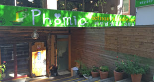
Garosoo-gil in Korean (가로수길) means a tree-lined street. The most famous avenue with this moniker is in the ritzy Sinsa-dong in Seoul, but Changwon has its own Garosoo-gil in Yongji-dong, near Yongji Lake. The official name of the street is 용지로239번길 (Yongji-ro 239 beon-gil), but it’s more commonly known to …
Read More »
April 30, 2014
Activity, Culture, Exercise, Maps
If you’ve been looking for a fun and active way to get some exercise, learn a new skill, and engage in part of Korean culture, now is as good a time as any to pick up martial arts! Korea is well-known for taekwondo, of course, but there are many other …
Read More »
April 1, 2014
Activity, Bars, Better-Know-a-Dong, Festivals, Hiking, Korean Restaurants, Maps, Parks, Temples
Some current updated links for information on the 2019 Festival: Official Tourism Website JinHae Cherry Blossom Festival on Twitter Changwon City Official Blog View Jinhae (진해) in a larger map Known for the Cherry Blossom Festival, Jinhae, or sometimes Chinhae (진해), is the smallest and southernmost city in the …
Read More »
February 13, 2014
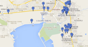
Better-Know-a-Dong, Maps
Here is the beginnings to our Jinhae Map! Use the link below to see the full map, and all the wonderful information on how to get there. If you have things to add, please send us a message! Thanks! View Jinhae (진해) in a larger map
Read More »
July 17, 2013
City Info, Essentials, Government Offices, Maps
The new immigration office sits in bureaucratic hiding towards the Free Trade Area of Masan. The short move: 300 yards down the street, seems to have invigorated the staff and instilled some efficiency. To get there, taking a bus is only around 5 minutes longer than a taxi, although a …
Read More »
June 24, 2013
City Buses, Maps, Translations, Travel
Part two! In the first post I explained how to search for directions, but didn’t really go into some of the many things that Daum maps can do. In this post I will cover how to search for things or services that you might find yourself needing while in Korea. …
Read More »
June 24, 2013
City Buses, Maps, Translations, Travel
Since I first arrived in Korea, I have gone through several different methods of trying to keep track of bus numbers and how to navigate the bus system. At first, I kept a handy list of all the routes that went to my school and places that I often frequented. …
Read More »
June 5, 2013
About Changwon, Hiking, Maps, Parks
This map has it all. Really. If you are new to the area, or starting to look for new places to explore, check out this fantastic map. Have some places to add? Open up the map in a larger view (below) and send a message to Steve. He generously opens …
Read More »
February 22, 2013
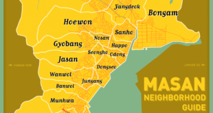
About Changwon, Maps
Continuing the task of mapping out Changwon’s neighborhoods (dongs), here is our map of central Masan, including Masan-happo gu and Masan-hoewon gu. Unlike our central Changwon map, we were able to track down the actual neighborhood borders, thanks to the korean-language version of Masan’s wikipedia pages (1, 2). For the …
Read More »
February 5, 2013
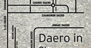
About Changwon, Maps
Ever wonder what a ‘daero’ (대로) is? It’s a big road. They’re all over town. Most famous in Changwon is Changwon Daero. This is the large, extremely straight road north of industrial complex. If you’ve ever wondered what or where they are, use this simplified map!
Read More »
November 15, 2012
Hiking, Maps
Changwon has so many mountains! This homemade map will hopefully make it easier to remember.
Read More »
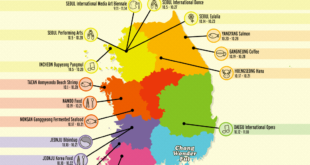
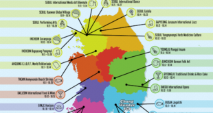
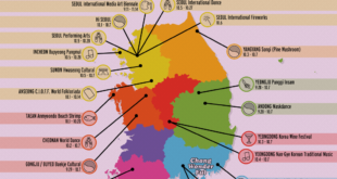
October 18, 2012
Calendars, Festivals, Maps
October in Korea is full of festivals! Here’s a map detailing when and where some festivals are for the weekend of October 6th and 7th. We put it together using Korean Tourism Org’s database. Please note that not all festivals appear there, and thus we have a difficult time tracking everything …
Read More »
October 10, 2012
Calendars, Festivals, Maps
October in Korea is full of festivals! Here’s a map detailing when and where some festivals are for the weekend of October 6th and 7th. We put it together using Korean Tourism Org’s database. Please note that not all festivals appear there, and thus we have a difficult time tracking everything …
Read More »
September 27, 2012
Calendars, Festivals, Maps
October in Korea is full of festivals! Here’s a map detailing when and where some festivals are for the weekend of October 6th and 7th. We put it together using Korean Tourism Org’s database. Please note that not all festivals appear there, and thus we have a difficult time tracking …
Read More »
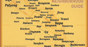
August 27, 2012
About Changwon, Maps
We proudly present to you a map of neighborhoods (dong) in the central Changwon area (Uichang gu and Seongsan gu). This map features the approximate locations of each neighborhood, using information gleaned from Google maps. These neighborhoods are the smaller, colloquial dongs, as detailed in Changwon’s Neighborhood System, and thus, much …
Read More »
April 22, 2012
Intercity Buses, Maps
The Masan Nambu Shiwae Bus Terminal (마산남부시외버스터미널) services two provinces. The following country map attempts to catalogue the current service times and locations, as of April, 2012. Additionally, extra stops before destinations are listed. To download a large version, place your cursor over the image and select the download option …
Read More »
April 22, 2012
Intercity Buses, Maps
The Masan Gosok Bus Terminal (마산고속버스터미널) services four provinces. The following country map attempts to catalogue the current service times and locations, as of April, 2012. Additionally, extra stops before destinations are listed. To download a large version, place your cursor over the image and select the download option at …
Read More »
April 20, 2012
Intercity Buses, Maps
The Masan Shiwae Bus Terminal (마산시외버스터미널) services eight provinces. The following country map attempts to catalogue the current service times and locations, as of April, 2012. Additionally, extra stops before destinations are listed. To download a large version, place your cursor over the image and select the download option at …
Read More »
April 20, 2012
Intercity Buses, Maps
The Changwon Bus Terminal (창원버스터미널) services eight provinces. The following country map attempts to catalogue the current service times and locations, as of April, 2012. Additionally, extra stops before destinations are listed. To download a large version, place your cursor over the image and select the download option at the …
Read More »
 Changwonderful